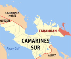
 Caramoan is a first-class municipality in the province of Camarines Sur, Bicol Region, Philippines. It is located at the tip of the Caramoan Peninsula, a rugged place of land extending into the waters of the Maqueda Channel on the north and east and Lagonoy Gulf on the south. According to the 2010 census, it has a population of 44,945 people.
Caramoan is bounded on the north by the town of Garchitorena and the Philippine Sea of the Pacific Ocean; on the northeast by the island province of Catanduanes; on the south by Lagonoy Gulf; on the east by the Maqueda Channel and on the west by the municipality of Presentacion.
The municipality covers approximately 277.41 square kilometres (107.11 sq mi) with approximately 71 kilometres (44 mi) of irregular coastline surrounded by the vast ocean, bay, seas and swamps. It is approximately 500 kilometres (310 mi) from Metro Manila; 95 kilometres (59 mi) from the municipality of Pili, where the seat of the provincial government and the Naga Domestic Airport are located; and 110 kilometres (68 mi) east from Naga City, the heart of Bicol.
HISTORY OF CARAMOAN

Caramoan is known to be an old town. It was discovered by a Spanish missionary named Fray Francisco de la Cruz y Oropesa. He found a settlement called Balwarte as he explored the town’s wilderness. Based on history, the place was subsequently under the jurisdiction of Sagrada Mitra in 1696. It was during this period when a parish was established dedicated to St. Michael the Archangel. His feast day is celebrated every May 8. There are different versions of how Caramoan got its name. But it became known that it officially used its present name since 1619.
Since 1619, the name Caramoan has been officially used. That same year, it was named as such by a Spanish missionary friar called Francisco de la Cruz Y Oropesa. When Fr. Oropesa penetrated the thick virgin forest of the Caramoan Peninsula, he established a small settlement known as Baluarte. Subsequently, this settlement was turned over to the administration of the Holy Bishopric in 1696.
Before the arrival of the Spaniards, it was discovered that the place used to be called Guta de Leche. It was given by the Dutch traders who operated a gold mine in Lahuy Island. They frequented the area in order to trade with the natives. Perhaps, the name was derived from the milk drop stalagmites present in the rocks of Guta Port. When the Spaniards arrived, the place was called “Carahan”. At that time, plenty of sea turtles where present along the Peninsula shore.
The original name of the town is Gota de Leche as provided by the Dutch merchants. Such name is derived from the milk-like droplets of the stalagmite present in rocks of the place known as Gota Port. Later, it was changed into Caramoan. This time, it was labeled by the Spaniards. They derived this word from ‘carahan’ which is a type of sea turtle abundantly present in the shores of the area at that time. Several other tales were based on the name of this peninsula. Caramoan is a town of Camarines Sur province which is apparently blessed with untapped natural resources. It is rich with numerous mineral deposits such as marble in different colors, copper, limestone, gold and manganese. In addition, it has long miles of sugary, white beaches which can even compete with the world’s best beaches. It can also attract foreign and local investors from the tourism industry providing a virtual advantage to this town. Consequently, its economic condition is enhanced. According to vigorous research in history, this town is where Francisco Alvarez came from. He was known to be the most senior and experienced among the Bikolano assemblymen. Currently, plans are directed in improving this municipality. Such move is made by the provincial government through the efforts of Governor Luis Villafuerte. Examples of these plans are cementing and asphalting the Caramoan Peninsula Road as well as establishing a ferry system between Catanduanes and Camarines Sur.
References:
1. http://en.wikipedia.org/wiki/Caramoan,_Camarines_Sur
2. http://www.caramoan.ph/history-of-caramoan/

No comments:
Post a Comment